861 Hits for February 2013
Albums (0) & Images (861)
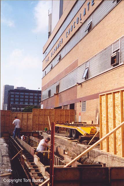
tb_blommer_08282002_01
Rebuilding the lower-level Blommer spur along the east side of the factory building. The old tracks were in terrible shape. This work crew appears to be installing a vault below and between the rails for receiving inbound loads from railcars directly into the factory. Other candy companies use chutes between the rails and into the building (Reed Candy and Peerless Confectionary along the Milwaukee Road's Lakewood tracks for example) to receive corn syrup.tb_blommer_08282002_01
Rebuilding the lower-level Blommer spur along the east side of the
factory building. The old tracks were in terrible shape. This work
crew appears to be installing a vault below and between the rails
for receiving inbound loads from railcars directly into the
factory. Other candy companies use chutes between the rails and
into the building (Reed Candy and Peerless Confectionary along the
Milwaukee Road's Lakewood tracks for example) to receive corn
syrup.

tb_blommer_08282002_02
Another view of the reconstruction of Blommer's lower-level spurtb_blommer_08282002_02
Another view of the reconstruction of Blommer's lower-level spur
tb_blommer_08282002_03
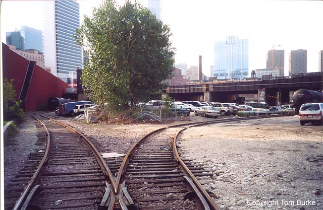
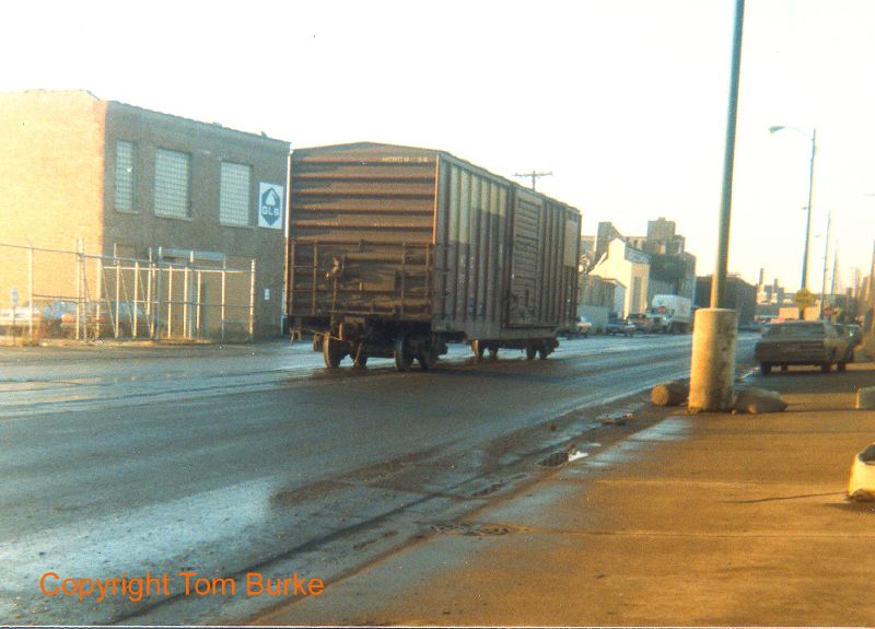
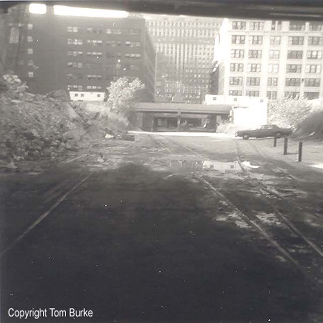
Former junction point on the UP (ex-C&NW) with the Navy Pier line veering off to the left (east), and the Blommer spur on the right (west). This view looks south from about Grand Avenue in Chicago, with the huge Chicago Tribune Freedom Center printing plant behind the camera. The Tribune receives large inbound loads of newsprint via boxcars on the UP. It looks like the former line to Navy Pier is being used for storage of tank cars, as well as the Blommer spur. The left track was used to reach the former Navy Pier line from 1988 to abandonment in early 2002.tb_blommer_08282002_03
Former junction point on the UP (ex-C&NW) with the Navy Pier
line veering off to the left (east), and the Blommer spur on the
right (west). This view looks south from about Grand Avenue in
Chicago, with the huge Chicago Tribune Freedom Center printing
plant behind the camera. The Tribune receives large inbound loads
of newsprint via boxcars on the UP. It looks like the former line
to Navy Pier is being used for storage of tank cars, as well as the
Blommer spur. The left track was used to reach the former Navy Pier
line from 1988 to abandonment in early 2002.
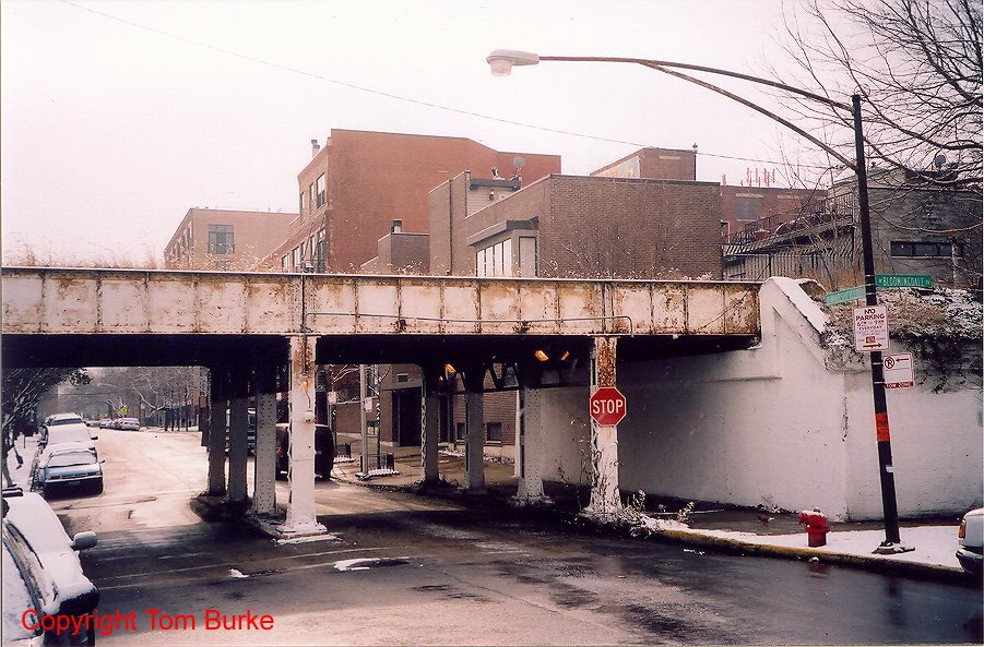
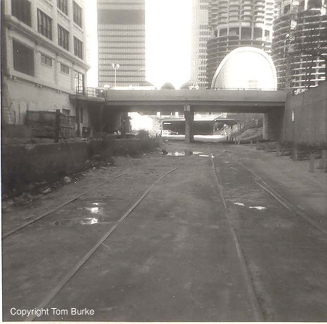
tb_bloomingdale_12012005_01
The Milwaukee Road's Bloomingdale Line sits dormant today with its viaduct cutting across Chicago's West Side for several miles. It parallels Bloomingdale Avenue most of the way.Until 2001 Milwaukee Road successor CP Rail/Soo Line used the Bloomingdale Line to access remaining freight customers on Chicago's North Side. Now CP Rail leases space in UP's North Ave. yard instead and crews are shuttled to work.
This view looks southwest at Marshfield and Bloomingdale, just a block west of Ashland Avenue and the Kennedy Expressway. Just to the east was where the Bloomingdale Line crossed the busy C&NW/UP/Metra line near Tower CY.
The Bloomingdale Line is similar to the former New York Central "High Line" in New York City which is being converted to public use on its viaduct.
tb_bloomingdale_12012005_01
The Milwaukee Road's Bloomingdale Line sits dormant today with its
viaduct cutting across Chicago's West Side for several miles. It
parallels Bloomingdale Avenue most of the way.
Until 2001 Milwaukee Road successor CP Rail/Soo Line used the Bloomingdale Line to access remaining freight customers on Chicago's North Side. Now CP Rail leases space in UP's North Ave. yard instead and crews are shuttled to work.
This view looks southwest at Marshfield and Bloomingdale, just a block west of Ashland Avenue and the Kennedy Expressway. Just to the east was where the Bloomingdale Line crossed the busy C&NW/UP/Metra line near Tower CY.
The Bloomingdale Line is similar to the former New York Central "High Line" in New York City which is being converted to public use on its viaduct.
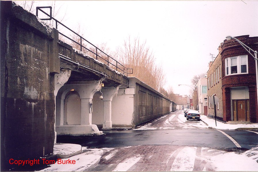
tb_bloomingdale_12012005_02
Another view of the Bloomingdale Line a few blocks west. Note the brick paved street on Bloomingdale Avenue. The tracks and the top of the viaduct are not accessible to the public thanks to high fences and the steep concrete walls.tb_bloomingdale_12012005_02
Another view of the Bloomingdale Line a few blocks west. Note the brick paved street on Bloomingdale Avenue. The tracks and the top of the viaduct are not accessible to the public thanks to high fences and the steep concrete walls.
tb_bloomingdale_12012005_03
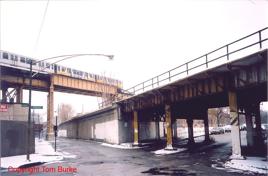
We're looking east at the CTA Blue Line which crosses over the former Milwaukee Road Bloomingdale Line at-how appropriate-Milwaukee Avenue!tb_bloomingdale_12012005_03
We're looking east at the CTA Blue Line which crosses over the
former Milwaukee Road Bloomingdale Line at-how
appropriate-Milwaukee Avenue!
tb_bloomingdale_12012005_04
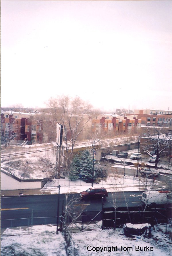
A CTA train is the best way to get a birds-eye view of the Bloomingdale Line. This shot looks towards the southwest.tb_bloomingdale_12012005_04
A CTA train is the best way to get a birds-eye view of the Bloomingdale Line. This shot looks towards the southwest.
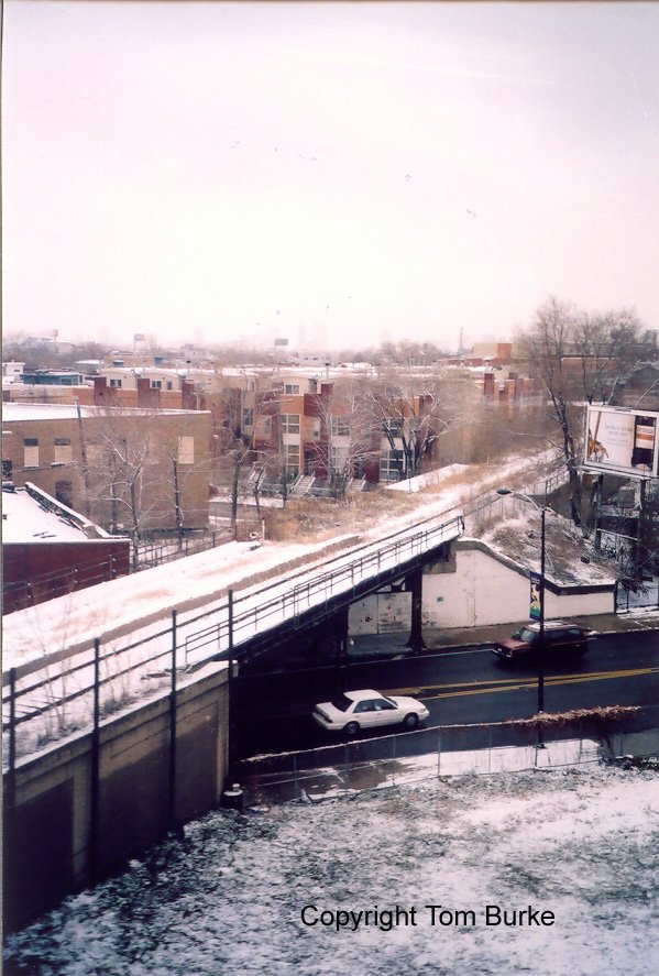
Another view looking west from a CTA train.
tb_bloomingdale_12012005_06
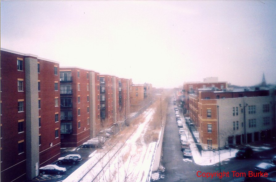
On the return trip, the camera this time points east along the Bloomingdale Line. Note the new residential construction on both sides.
tb_bloomingdale_12012005_06
On the return trip, the camera this time points east along the Bloomingdale Line. Note the new residential construction on both sides.
tb_boxcarkingsbury_1987_1
Also in 1987 a lone boxcar is left in the middle of the street just south of the Plibrico plant on Kingsbury. Perhaps the Soo Line crew left it there while attending to switching duties on Goose Island or farther down the C&E Line at Wallace Business Forms. In 1987 there was still a variety of customers that would receive or ship out via boxcars.
tb_boxcarkingsbury_1987_1
Also in 1987 a lone boxcar is left in the middle of the street just
south of the Plibrico plant on Kingsbury. Perhaps the Soo Line crew
left it there while attending to switching duties on Goose Island
or farther down the C&E Line at Wallace Business Forms. In 1987
there was still a variety of customers that would receive or ship
out via boxcars.
tb_CarrollAve_101984_01
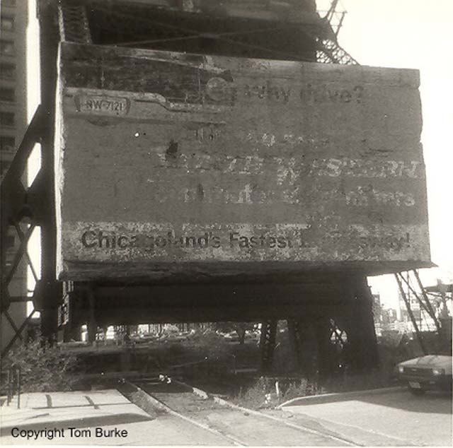
This picture looks west at the counterweight used on the C&NW's Kinzie Street bridge over the Chicago River. Note the 'Why Drive' ad with the picture of a 1960s auto painted by the C&NW on the counterweight. This sign would've been visible to potential rail commuters around the Merchandise Mart before the Apparel Center was built, spoiling this view. Today (2003) this sign has all but faded away.
tb_CarrollAve_101984_01
This picture looks west at the counterweight used on the C&NW's
Kinzie Street bridge over the Chicago River. Note the 'Why Drive'
ad with the picture of a 1960s auto painted by the C&NW on the
counterweight. This sign would've been visible to potential rail
commuters around the Merchandise Mart before the Apparel Center was
built, spoiling this view. Today (2003) this sign has all but faded
away.
tb_CarrollAve_101984_02
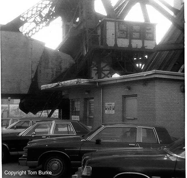
Here's a view of the structures used by the bridge tender on the C&NW's bascule bridge over the river.
tb_CarrollAve_101984_02
Here's a view of the structures used by the bridge tender on the
C&NW's bascule bridge over the river.
tb_CarrollAve_101984_03
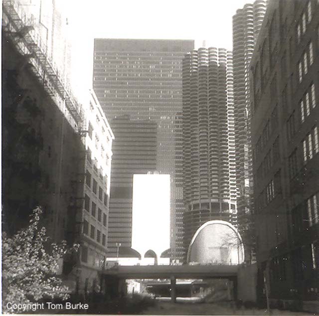
Looking east down Carroll Avenue along the C&NW tracks, we can see the Clark St. bridge and just past it, the twin towers of Marina City and the looming, black IBM building. The Quaker Oats Tower hasn't been built yet. In a few years it would cover Carroll Avenue and create another tunnel for the North Western trains just past Clark St.
tb_CarrollAve_101984_03
Looking east down Carroll Avenue along the C&NW tracks, we can
see the Clark St. bridge and just past it, the twin towers of
Marina City and the looming, black IBM building. The Quaker Oats
Tower hasn't been built yet. In a few years it would cover Carroll
Avenue and create another tunnel for the North Western trains just
past Clark St.
tb_CarrollAve_101984_05
This view looks west down Carroll Ave. and the C&NW tracks towards the Merchandise Mart. The Clark St. bridge is just ahead. Work appears to be underway to the left on the new Quaker Oats headquarters building which will cover up the location soon. Note the old spur on the left with the ties used as a bumping post. These multiple tracks would be reduced to one, new section poured in concrete once the Quaker Oats building was built.
tb_CarrollAve_101984_05
This view looks west down Carroll Ave. and the C&NW tracks
towards the Merchandise Mart. The Clark St. bridge is just ahead.
Work appears to be underway to the left on the new Quaker Oats
headquarters building which will cover up the location soon. Note
the old spur on the left with the ties used as a bumping post.
These multiple tracks would be reduced to one, new section poured
in concrete once the Quaker Oats building was built.
tb_CarrollAve_101984_07
A closer look at the tracks just west of Clark St. Traffic court is on the right. Note the loading dock and spur track to the left (north), and how this spur and another one that veers off from the main track appear to criss-cross each other. Must have made for some interesting switching when more industries were in the area.
tb_CarrollAve_101984_08
Looking west at the Merchandise Mart and Franklin St. Note the original two tracks are still in place, though only the left side set is still in service for trains of newsprint for the Sun-Times. To the upper left is the Helene Curtis headquarters building. The other sides of the parking garage and the Helene Curtis face the Chicago River.