861 Hits for February 2013
Albums (0) & Images (861)
tb_NorthBranch_1988_04
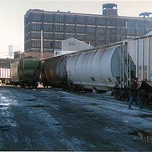
A CP Rail train returns with empty hoppers from Akzo Salt late on a January afternoon in 1990, passing under the closed Ogden Avenue overpass along North Branch Street. This shot shows the terrible shape of the roadbed on the track to Akzo just prior to its rebuilding. Note the lack of ballast or paving around the tracks where North Branch basically was paved in dirt at this time. Prior to the late 1980s this track saw very little action, perhaps one car a year to keep it open, according to the train crew. Siltation on the Chicago River forced International Salt, and later Akzo, to shift to railcars from ships for incoming salt deliveries during this timeframe.tb_NorthBranch_1988_04
A CP Rail train returns with empty hoppers from Akzo Salt late on a January afternoon in 1990, passing under the closed Ogden Avenue overpass along North Branch Street. This shot shows the terrible shape of the roadbed on the track to Akzo just prior to its rebuilding. Note the lack of ballast or paving around the tracks where North Branch basically was paved in dirt at this time. Prior to the late 1980s this track saw very little action, perhaps one car a year to keep it open, according to the train crew. Siltation on the Chicago River forced International Salt, and later Akzo, to shift to railcars from ships for incoming salt deliveries during this timeframe.
tb_NorthBranch_1988_05
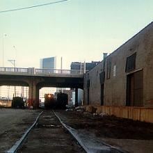
This busy shot from January 1990 looks east and again shows the poor condition of the tracks in North Branch Street that ran to Akzo Salt just prior to reconstruction. Business is strong at this time for CP Rail at Akzo Salt as evidenced by the multiple covered hoppers with inbound salt loads. Compare this "before" shot to the next photo taken 18 months later...tb_NorthBranch_1988_05
This busy shot from January 1990 looks east and again shows the
poor condition of the tracks in North Branch Street that ran to
Akzo Salt just prior to reconstruction. Business is strong at this
time for CP Rail at Akzo Salt as evidenced by the multiple covered
hoppers with inbound salt loads. Compare this "before" shot to the
next photo taken 18 months later...
tb_NorthBranch_1988_06
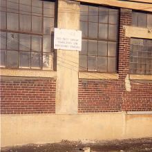
Sign on this North Branch Street building between Akzo Salt and Midwest Industrial Metals warns "NOTICE: DO NOT DROP TRAILERS ON RAILROAD TRACKS." CP Rail and prior to that, Milwaukee Road trains had to make a tricky backup move to locate cars in the Midwest Industrial Metals spur just to the left of this picture on North Branch just north of the Ogden Avenue overpass on Goose Island. By 1999 this sign lost its meaning as active freight operations retreated further north to Big Bay Lumber and truck trailers now park across the tracks without any interference from trains. This photo dates from January 1990.tb_NorthBranch_1988_06
Sign on this North Branch Street building between Akzo Salt and
Midwest Industrial Metals warns "NOTICE: DO NOT DROP TRAILERS ON
RAILROAD TRACKS." CP Rail and prior to that, Milwaukee Road trains
had to make a tricky backup move to locate cars in the Midwest
Industrial Metals spur just to the left of this picture on North
Branch just north of the Ogden Avenue overpass on Goose Island. By
1999 this sign lost its meaning as active freight operations
retreated further north to Big Bay Lumber and truck trailers now
park across the tracks without any interference from trains. This
photo dates from January 1990.
tb_nthblmt_0386_10
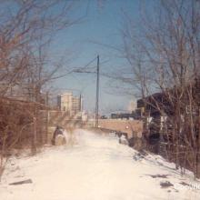
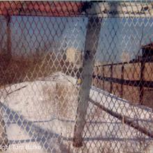
Looking north at the ramp which led up to the L from the Buena Yard and interchange with the Milwaukee Road's C&E line. (March 1986)tb_nthblmt_0386_10
Looking north at the ramp which led up to the L from the Buena Yard
and interchange with the Milwaukee Road's C&E line. (March
1986)
tb_nthblmt_0386_11
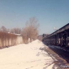
CTA freight tracks on the bridge over Montrose Avenue. Until 1973 this bridge served as the connection for freight service between the "L" and the Milwaukee Road. This view looks north at the two remaining interchange tracks. Overhead catenary support columns can still be seen. The catenary system brought electrical power all the way down to the lower Buena Yard for the CTA's electric freight locomotives. The CTA's predecessor took over responsibility for serving the Milwaukee Road's freight customers north of Montrose Avenue through Evanston whenthe ROW was raised onto viaducts and leased to the elevated lines by the Milwaukee Road decades before. The original name of this Milwaukee Road line was the Chicago & Evanston, and the "C&E" title was used by Milwaukee Road crews to designate the tracks on Kingsbury and Lakewood into the Soo Line era of ownership in 1986. (March 1986)tb_nthblmt_0386_11
CTA freight tracks on the bridge over Montrose Avenue. Until 1973
this bridge served as the connection for freight service between
the "L" and the Milwaukee Road. This view looks north at the two
remaining interchange tracks. Overhead catenary support columns can
still be seen. The catenary system brought electrical power all the
way down to the lower Buena Yard for the CTA's electric freight
locomotives. The CTA's predecessor took over responsibility for
serving the Milwaukee Road's freight customers north of Montrose
Avenue through Evanston whenthe ROW was raised onto viaducts and
leased to the elevated lines by the Milwaukee Road decades before.
The original name of this Milwaukee Road line was the Chicago &
Evanston, and the "C&E" title was used by Milwaukee Road crews
to designate the tracks on Kingsbury and Lakewood into the Soo Line
era of ownership in 1986. (March 1986)
tb_nthblmt_0387_09
Ahead is the former location of the Buena Yard at Irving Park road where freight interchange took place between the CTA and the Milwaukee Road-and for a time, the North Shore Line interurban line used the yard for early piggyback service. Graceland Cemetary is on the left or west. According to crews, this could be a rough area to work at night. (March 1986)tb_nthblmt_0387_09
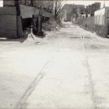
Ahead is the former location of the Buena Yard at Irving Park road where freight interchange took place between the CTA and the Milwaukee Road-and for a time, the North Shore Line interurban line used the yard for early piggyback service. Graceland Cemetary is on the left or west. According to crews, this could be a rough area to work at night. (March 1986)
tb_nthblmt_042602_01
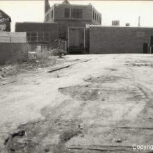
This April 26, 1987, view looks south from Melrose Avenue towards Belmont Avenue and beyond. This view is taken from the other end of the same tail track shown in the north to Belmont section. Note the former battery box on the left for the battered grade crossing signal on the right. This segment of track north of Belmont was retained up to Melrose by the Milwaukee Road as a tail track for backing cars down Reed Candy's spur just south of Belmont Ave. after rail service was cut back around 1982 from Racine Ave. to Melrose. In the distant background is the towering Best Brewing Company complex, now a renovated rental property with upscale apartments. Best Brewing was serviced by the Milwaukee Road into the early 1960s when it went out of business. On the right are the buildings of Lakeview Metals which was also serviced by the Milwaukee Road at one time. Today a strip shopping center facing Belmont Ave. occupies the foreground of this picture.tb_nthblmt_042602_01
This April 26, 1987, view looks south from Melrose Avenue towards
Belmont Avenue and beyond. This view is taken from the other end of
the same tail track shown in the north to Belmont section. Note the
former battery box on the left for the battered grade crossing
signal on the right. This segment of track north of Belmont was
retained up to Melrose by the Milwaukee Road as a tail track for
backing cars down Reed Candy's spur just south of Belmont Ave.
after rail service was cut back around 1982 from Racine Ave. to
Melrose. In the distant background is the towering Best Brewing
Company complex, now a renovated rental property with upscale
apartments. Best Brewing was serviced by the Milwaukee Road into
the early 1960s when it went out of business. On the right are the
buildings of Lakeview Metals which was also serviced by the
Milwaukee Road at one time. Today a strip shopping center facing
Belmont Ave. occupies the foreground of this picture.
tb_nthblmt_042687_04
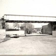
A view taken just three years later on April 26, 1987, from the same location.tb_nthblmt_042687_04
A view taken just three years later on April 26, 1987, from the same location.
tb_nthblmt_042687_06
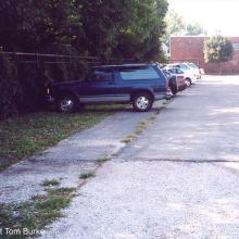
The Milwaukee Road traveled underneath a bridge carrying the CTA's Ravenswood line. It won't be much longer until townhomes and condos fill in the ROW. Until then the old ROW was used for Wrigley Field parking on game days. This view looks north from about Racine Ave. April 26, 1987. Piles of junk and abandoned cars will be a thing of the past as well soon.tb_nthblmt_042687_06
The Milwaukee Road traveled underneath a bridge carrying the CTA's
Ravenswood line. It won't be much longer until townhomes and condos
fill in the ROW. Until then the old ROW was used for Wrigley Field
parking on game days. This view looks north from about Racine Ave.
April 26, 1987. Piles of junk and abandoned cars will be a thing of
the past as well soon.
tb_nthblmt_091702_03
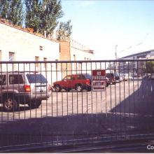
Finally, the same location, Sep. 17, 2002, also looking south. The grade crossing is gone, even the raised ROW where it crossed School as been removed. This location is the second of two on the former Milwaukee Road where rails still exist north of Diversey. Condos have taken over the ROW to the north.tb_nthblmt_091702_03
Finally, the same location, Sep. 17, 2002, also looking south. The grade crossing is gone, even the raised ROW where it crossed School as been removed. This location is the second of two on the former Milwaukee Road where rails still exist north of Diversey. Condos have taken over the ROW to the north.
tb_nthblmt_091702_07
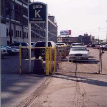
This view looks north from Cornelia towards Wrigley Field and shows the ROW as it bends gently to the east. (Sep. 17, 2002)tb_nthblmt_091702_07
This view looks north from Cornelia towards Wrigley Field and shows the ROW as it bends gently to the east. (Sep. 17, 2002)
tb_nthblmt_091702_08
A pair of Milwaukee Road tracks appear in front of Wrigley Field at Waveland Ave. almost three decades after service was ended past Addison. One of only two locations where former Milwaukee Road C&E line rails can still be seen north of Diversey Ave.! A coal yard and a team track were once customers nearby. Even the Chicago Cubs received carloads of bats in the spring from the Milwaukee Road ages ago. (Sep. 17, 2002)tb_nthblmt_091702_08
A pair of Milwaukee Road tracks appear in front of Wrigley Field at
Waveland Ave. almost three decades after service was ended past
Addison. One of only two locations where former Milwaukee Road
C&E line rails can still be seen north of Diversey Ave.! A coal
yard and a team track were once customers nearby. Even the Chicago
Cubs received carloads of bats in the spring from the Milwaukee
Road ages ago. (Sep. 17, 2002)
tb_nthblmt_1984_05
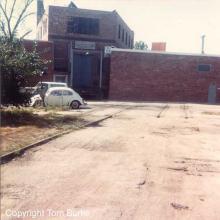
Three views taken over time from the same position . This first picture dates from 1984 and looks south down the recently abandoned Milwaukee Road ROW towards School St. The building across the ROW was put up right after operations ended north of Belmont in the early 1980s, giving the appearance that they run into the structure. The grade crossing signal on the left is still in place. Note how toward the end of operations the Milwaukee Road was down to single track operation on the far left, using the former northbound main.tb_nthblmt_1984_05
Three views taken over time from the same position . This first picture dates from 1984 and looks south down the recently abandoned Milwaukee Road ROW towards School St. The building across the ROW was put up right after operations ended north of Belmont in the early 1980s, giving the appearance that they run into the structure. The grade crossing signal on the left is still in place. Note how toward the end of operations the Milwaukee Road was down to single track operation on the far left, using the former northbound main.
tb_nthblmt_1985_02
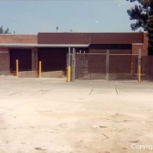
Looking north this time across Melrose Avenue at the same building across the ROW. These tracks are gone now. (June 1986)tb_nthblmt_1985_02
Looking north this time across Melrose Avenue at the same building across the ROW. These tracks are gone now. (June 1986)
tb_openingweek_2jan2007_01
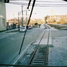
View of northern end of Goose Island as viewed from back of the SW-8.tb_openingweek_2jan2007_01
View of northern end of Goose Island as viewed from back of the SW-8.
tb_openingweek_2jan2007_02
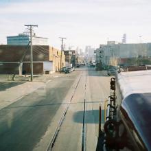
View from the SW-8 of the C&E South Line, no longer in use to the left and Chicago's skyline. The locomotive is turning onto the Goose Island lead in Kingsbury St.tb_openingweek_2jan2007_02
View from the SW-8 of the C&E South Line, no longer in use to
the left and Chicago's skyline. The locomotive is turning onto the
Goose Island lead in Kingsbury St.