861 Hits for February 2013
Albums (0) & Images (861)
mk_connector_1991_08
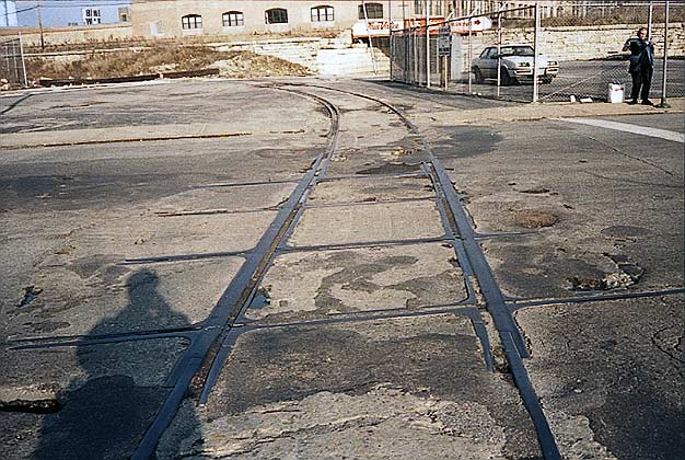
Good view looking east of the C&NW connecting track where it crossed Clybourn Ave. and the former Chicago Surface Lines streetcar tracks. Some 33 years after abandonment, the streetcar tracks and frogs where they crossed the heavier rails of the C&NW are still there in 1991.mk_connector_1991_08
Good view looking east of the C&NW connecting track where it
crossed Clybourn Ave. and the former Chicago Surface Lines
streetcar tracks. Some 33 years after abandonment, the streetcar
tracks and frogs where they crossed the heavier rails of the
C&NW are still there in 1991.

Damen Ave. bridge view looking southeast.

mk_damenbrdg_1991_03
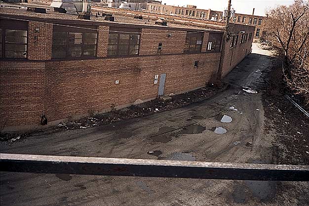
A continuation of the previous photo. Here the spur wraps around the building then heads to the northwest up an alley along the Chicago River (out of picture to the right), parallel to N. Elston Ave. Eventually it swung west across Elston and connected with the CNW's Northwest Line. An intricate network of street trackage once existed in this district.mk_damenbrdg_1991_03
A continuation of the previous photo. Here the spur wraps around
the building then heads to the northwest up an alley along the
Chicago River (out of picture to the right), parallel to N. Elston
Ave. Eventually it swung west across Elston and connected with the
CNW's Northwest Line. An intricate network of street trackage once
existed in this district.

mk_damenbrdg_1991_04
View from the Damen Avenue bridge looking west down an alley to a tennis club on N. Elston Ave. (just NW of W. Fullerton Ave.) Note spur remnant in weeds along the fence, curving toward the building on the right. This spur likely branched off the CNW's Northwest Line (see next photo).mk_damenbrdg_1991_04
View from the Damen Avenue bridge looking west down an alley to a
tennis club on N. Elston Ave. (just NW of W. Fullerton Ave.) Note
spur remnant in weeds along the fence, curving toward the building
on the right. This spur likely branched off the CNW's Northwest
Line (see next photo).
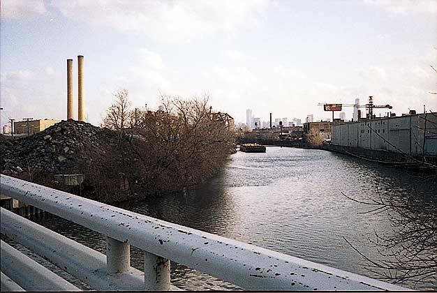
mk_deeringbrdg_1991_01
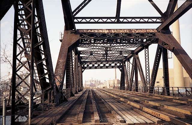
C&NW's North Line bascule bridge over the Chicago River. This scene is substantially different today.mk_deeringbrdg_1991_01
C&NW's North Line bascule bridge over the Chicago River. This
scene is substantially different today.


mk_deeringbrdg_1991_03
This Cement Plant is south of Fullerton at the Chicago River. The Milwaukee Road's Deering Line crossed through here prior to cutbacks around 1982. The site is now a Shopping Center. The view looks west of the C&NW north linemk_deeringbrdg_1991_03
This Cement Plant is south of Fullerton at the Chicago River. The
Milwaukee Road's Deering Line crossed through here prior to
cutbacks around 1982. The site is now a Shopping Center. The view
looks west of the C&NW north line

mk_deeringbrdg_1991_04
C&NW's North Line looking south. It crossed over the Milwaukee Road's Deering Line here just before the bascule bridge. The stone abutments and bridge over the former Milwaukee Road branch line are still there, behind the T.J. Maxx store off Fullerton. Note the former C&NW industrial lead track taken up on the right.mk_deeringbrdg_1991_04
C&NW's North Line looking south. It crossed over the Milwaukee
Road's Deering Line here just before the bascule bridge. The stone
abutments and bridge over the former Milwaukee Road branch line are
still there, behind the T.J. Maxx store off Fullerton. Note the
former C&NW industrial lead track taken up on the right.
mk_deeringbrdg_1991_05
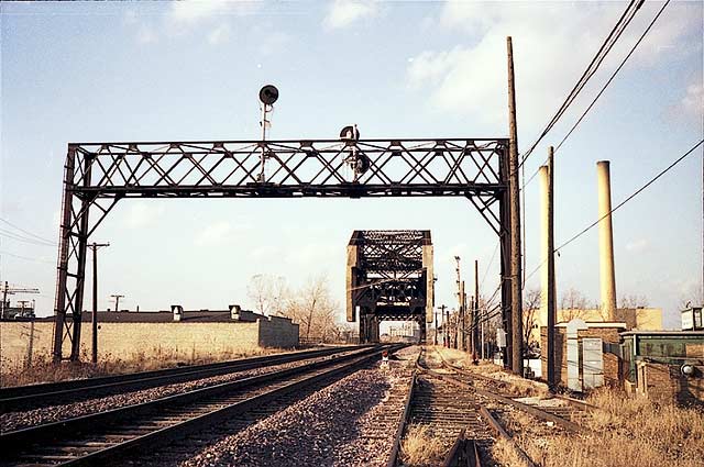
Looking north this time towards the C&NW North Line bridge over the Chicago River. The spur in the foreground will drop down and cross busy Ashland Avenue at grade to reach Tanneries and industries on the west side of the river, north of Cortland and east of Ashland.mk_deeringbrdg_1991_05
Looking north this time towards the C&NW North Line bridge over
the Chicago River. The spur in the foreground will drop down and
cross busy Ashland Avenue at grade to reach Tanneries and
industries on the west side of the river, north of Cortland and
east of Ashland.
mk_diverseybrdg_1991_01
Looking southeast from the Diversey Blvd. bridge down the Chicago River. On the east (left) bank was the right-of-way of the Milwaukee Road's former Deering Line which crossed Diversey at one time. The former McCormick-Deering plant was located on the eastern side of the river between Diversey and Fullerton.mk_diverseybrdg_1991_01
Looking southeast from the Diversey Blvd. bridge down the Chicago
River. On the east (left) bank was the right-of-way of the
Milwaukee Road's former Deering Line which crossed Diversey at one
time. The former McCormick-Deering plant was located on the eastern
side of the river between Diversey and Fullerton.

mk_divsydamen_1991_01
A view of the northern end of the Cotter & Company plant on Clybourn taken from the Damen Ave. drawbridge. Cotter & Company was the parent for the True-Value (www.true-value.com) chain of hardware stores, pre-merger and name change, and had a huge complex of headquarters and factory buildings along Clybourn at one time before relocating.mk_divsydamen_1991_01
A view of the northern end of the Cotter & Company plant on
Clybourn taken from the Damen Ave. drawbridge. Cotter & Company was
the parent for the True-Value (www.true-value.com) chain of
hardware stores, pre-merger and name change, and had a huge complex
of headquarters and factory buildings along Clybourn at one time
before relocating.

Close-up of plaque on the iron press.

mk_finkls_1991_01
Old 300-ton iron press at Finkl Steel complex on N. Southport Ave.; this area is no longer accessible to the public.
mk_finkls_1991_01
Old 300-ton iron press at Finkl Steel complex on N. Southport Ave.; this area is no longer accessible to the public.
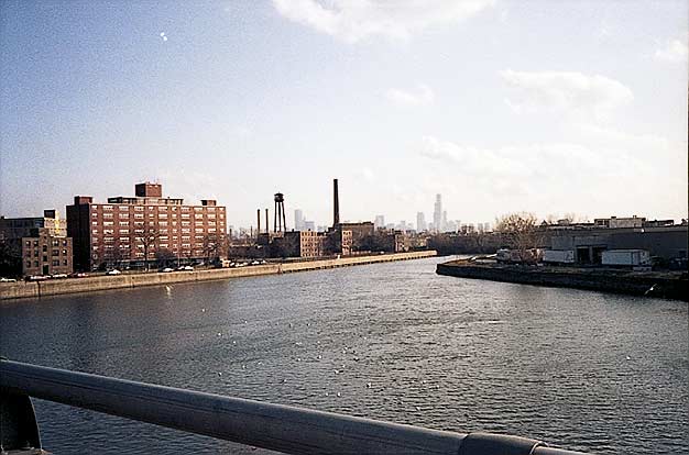
mk_fullertonbrdg_1991_01
We're on the Fullerton Ave. Bridge looking southeast down the Chicago River. The river is curving east as it meanders to Downtown. Today, the Medill Sanitation Facility is no longer there (on the left). CNW's north line bascule bridge is in the background just visible behind the trees.
mk_fullertonbrdg_1991_01
We're on the Fullerton Ave. Bridge looking southeast down the
Chicago River. The river is curving east as it meanders to
Downtown. Today, the Medill Sanitation Facility is no longer there
(on the left). CNW's north line bascule bridge is in the background
just visible behind the trees.

mk_goose_sep1991_14
On a pleasant Saturday morning in early September of 1991 the Friends of the Chicago River group conducted a walking tour of Goose Island.View looks E-SE at the Milwaukee Road's drawbridge over the North Branch Channel, a canal dug through local clay deposits by brickbuilders in the 1800s. This is what makes Goose Island an island.
mk_goose_sep1991_14
On a pleasant Saturday morning in early September of 1991 the
Friends of the Chicago River group conducted a walking tour of
Goose Island.
View looks E-SE at the Milwaukee Road's drawbridge over the North Branch Channel, a canal dug through local clay deposits by brickbuilders in the 1800s. This is what makes Goose Island an island.