25 Hits for December 2017
Albums (0) & Images (25)
deeringHarvesterWorks_01
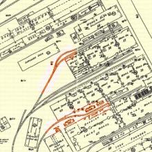
This historic map from 1923 shows the location of the spurs and the original names for the IH Deering Works buildings in the area. The tracks in red show the location of the spurs where the other photos were taken.deeringHarvesterWorks_01
This historic map from 1923 shows the location of the spurs and the original names for the IH Deering Works buildings in the area. The tracks in red show the location of the spurs where the other photos were taken.
tb_mrha_CandESouthLine_10_1980_01
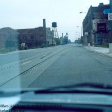
We're looking through the windshield of a car used by Milwaukee Road employees on this expedition in October of 1980 to document the C&E South Line and Goose Island. The car is facing north by northwest on Kingsbury Street near where Kingsbury ends at Halsted Street. On the left you can see a spur curving off the main track and veering to the west to reach the one-time J.W. Peterson coal yard. The remaining track from Halsted Street north to the Goose Island Lead north of North Avenue was officially abandoned by the Chicago Terminal in 2010 under a deal reached with the City of Chicago.tb_mrha_CandESouthLine_10_1980_01
We're looking through the windshield of a car used by Milwaukee
Road employees on this expedition in October of 1980 to document
the C&E South Line and Goose Island. The car is facing north by
northwest on Kingsbury Street near where Kingsbury ends at Halsted
Street. On the left you can see a spur curving off the main track
and veering to the west to reach the one-time J.W. Peterson coal
yard. The remaining track from Halsted Street north to the Goose
Island Lead north of North Avenue was officially abandoned by the
Chicago Terminal in 2010 under a deal reached with the City of
Chicago.
tb_mrha_CandESouthLine_10_1980_02
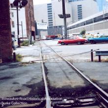
This view looks south by southeast across Grand Avenue at the end of the C&E South Line circa 1980. The original start of the C&E line was at Kinzie and Kingsbury a block farther south. Tracks used to continue in the right of the photograph across the space occupied by the East Bank Club and over the river. The East Bank Club is the long, grey-white, modern looking building and it was constructed over the former Milwaukee Road tracks and a small yard. The track that remains across Grand Avenue in 1980 is in place to serve as a tail track for backup moves into the Kirchheimer paper bag company. A time this track did double duty as a spur into the Hoppe Foundry as well as a tail track to reach Kirchheimer. The former Kirchheimer building still stands in 2010.tb_mrha_CandESouthLine_10_1980_02
This view looks south by southeast across Grand Avenue at the end
of the C&E South Line circa 1980. The original start of the
C&E line was at Kinzie and Kingsbury a block farther south.
Tracks used to continue in the right of the photograph across the
space occupied by the East Bank Club and over the river. The East
Bank Club is the long, grey-white, modern looking building and it
was constructed over the former Milwaukee Road tracks and a small
yard. The track that remains across Grand Avenue in 1980 is in
place to serve as a tail track for backup moves into the
Kirchheimer paper bag company. A time this track did double duty as
a spur into the Hoppe Foundry as well as a tail track to reach
Kirchheimer. The former Kirchheimer building still stands in 2010.
tb_mrha_CandESouthLine_10_1980_03
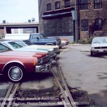
The camera is turned 180 degrees and we are now facing the roll-up, steel door protecting the entrance into the Kirchheimer building. The Milwaukee Road would shove cars into the building via this entrance, using the track behind it as a tail track for backing up and shoving forward to remove empties and push fresh loads. Looking at the rails it appears that a delivery was made rather recently. Thatís the Ohio/Ontario feeder ramp in the distance.tb_mrha_CandESouthLine_10_1980_03
The camera is turned 180 degrees and we are now facing the roll-up, steel door protecting the entrance into the Kirchheimer building. The Milwaukee Road would shove cars into the building via this entrance, using the track behind it as a tail track for backing up and shoving forward to remove empties and push fresh loads. Looking at the rails it appears that a delivery was made rather recently. Thatís the Ohio/Ontario feeder ramp in the distance.
tb_mrha_CandESouthLine_10_1980_04
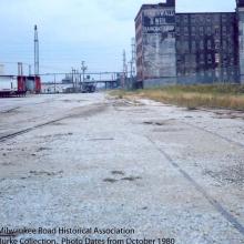
We are looking north by northwest on unimproved Kingsbury Street with the Ogden Avenue overpass in the distance. The setting is at roughly Hobbie Street and Kingsbury. National Tea, which received inbound shipments by rail into the early 1970s, once stood on the right where the chain link fence is in this photo. The large brick building is believed to be a survivor after later additions of the National Tea warehouse complex were torn down sometime, revealing the original owner with sign on the painted brick. In the distance on the left was a coffee company that received loads by rail years earlier. Farther north and past this brick building and to the right is a Commonwealth Edison facility that is still in place today. It was the scene of one of the last deliveries on the C&E South Line in late 1990 when a drop-center flatcar was dropped off with a piece of heavy electrical equipment. In 2004 there were still rails to be seen on this section. In 2010 it is mostly unrecognizable due to the new residential development in the area.tb_mrha_CandESouthLine_10_1980_04
We are looking north by northwest on unimproved Kingsbury Street
with the Ogden Avenue overpass in the distance. The setting is at
roughly Hobbie Street and Kingsbury. National Tea, which received
inbound shipments by rail into the early 1970s, once stood on the
right where the chain link fence is in this photo. The large brick
building is believed to be a survivor after later additions of the
National Tea warehouse complex were torn down sometime, revealing
the original owner with sign on the painted brick. In the distance
on the left was a coffee company that received loads by rail years
earlier. Farther north and past this brick building and to the
right is a Commonwealth Edison facility that is still in place
today. It was the scene of one of the last deliveries on the
C&E South Line in late 1990 when a drop-center flatcar was
dropped off with a piece of heavy electrical equipment. In 2004
there were still rails to be seen on this section. In 2010 it is
mostly unrecognizable due to the new residential development in the
area.
tb_mrha_CandESouthLine_10_1980_05
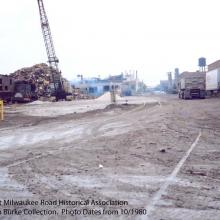
This view is taken at Kingsbury Street looking north from just south of the intersection with Wisconsin Avenue. At this time Kingsbury was paved in mud. It would be rebuilt in 1985. The main running track is on the left. The track mostly buried in the mud on the right is evidence that this area was once double-tracked during busier times.tb_mrha_CandESouthLine_10_1980_05
This view is taken at Kingsbury Street looking north from just south of the intersection with Wisconsin Avenue. At this time Kingsbury was paved in mud. It would be rebuilt in 1985. The main running track is on the left. The track mostly buried in the mud on the right is evidence that this area was once double-tracked during busier times.
tb_mrha_CandESouthLine_10_1980_06
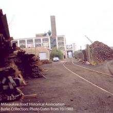
We're looking south down the Goose Island Lead which connected Goose Island to the C&E South Line. Straight ahead is North Avenue and just beyond that, a bridge that carried (and still carries in 2010) rail traffic to industries this man-made island. The brick building to the left is the former Glove Feather company, while the spur on the right once led to a Peopleís Gas facility with one of the characteristic checkerboard pattern storage tanks. After the gas storage tank was removed the site was used as a scrapyard.tb_mrha_CandESouthLine_10_1980_06
We're looking south down the Goose Island Lead which connected
Goose Island to the C&E South Line. Straight ahead is North
Avenue and just beyond that, a bridge that carried (and still
carries in 2010) rail traffic to industries this man-made island.
The brick building to the left is the former Glove Feather company,
while the spur on the right once led to a Peopleís Gas facility
with one of the characteristic checkerboard pattern storage tanks.
After the gas storage tank was removed the site was used as a
scrapyard.
tb_mrha_CandESouthLine_10_1980_07
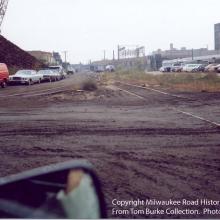
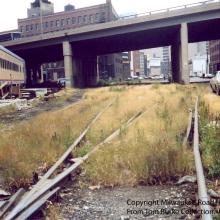
The Milwaukee Road photographer evidently decided to take this picture from his car versus getting muddy on Kingsbury Street! We are between Willow Street and North Avenue on Kingsbury. The track on the left or west is the Goose Island Lead while the track on the right is the ìmainlineî of the C&E South Line.tb_mrha_CandESouthLine_10_1980_07
The Milwaukee Road photographer evidently decided to take this
picture from his car versus getting muddy on Kingsbury Street! We
are between Willow Street and North Avenue on Kingsbury. The track
on the left or west is the Goose Island Lead while the track on the
right is the ìmainlineî of the C&E South Line.
tb_mrha_CandESouthLine_10_1980_08
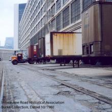
Looking south by southeast on the Milwaukee Roadís C&E South Line at roughly Erie Street and Kingsbury Street. Overhead is the Ohio/Ontario Feeder Ramp. At one time this area featured an extensive array of ladder tracks and spurs to allow switching to the many different industries as well as to get around freight cars spotted on the tracks. To the right a boxcar is seen spotted at the Wallace Business Forms building-the very last customer as it would turn out on this end of the C&E South Line. The tracks on the left continue across Grand Avenue to serve Kirshheimer and the Hoppe Foundry. Little is known about the Milwaukee Road coaches on the far left. When this area was rebuilt in 1985 by the City of Chicago all of the intricate tracks were 'rationalized' and were reduced to a single track that was really a very long spur to Wallace's loading docks. All other tracks including the one to Kirchheimer was removed. The Milwaukee Road passenger cars were relocated to a vacant lot on the west side of Kingsbury, under the feeder ramp. It is thought that they were part of a one-time restaurant-does anyone have any more information? Bill Denton models this area as part of his N-scale Kingsbury Line layout.tb_mrha_CandESouthLine_10_1980_08
Looking south by southeast on the Milwaukee Roadís C&E South
Line at roughly Erie Street and Kingsbury Street. Overhead is the
Ohio/Ontario Feeder Ramp. At one time this area featured an
extensive array of ladder tracks and spurs to allow switching to
the many different industries as well as to get around freight cars
spotted on the tracks. To the right a boxcar is seen spotted at the
Wallace Business Forms building-the very last customer as it would
turn out on this end of the C&E South Line. The tracks on the
left continue across Grand Avenue to serve Kirshheimer and the
Hoppe Foundry. Little is known about the Milwaukee Road coaches on
the far left. When this area was rebuilt in 1985 by the City of
Chicago all of the intricate tracks were 'rationalized' and were
reduced to a single track that was really a very long spur to
Wallace's loading docks. All other tracks including the one to
Kirchheimer was removed. The Milwaukee Road passenger cars were
relocated to a vacant lot on the west side of Kingsbury, under the
feeder ramp. It is thought that they were part of a one-time
restaurant-does anyone have any more information? Bill Denton
models this area as part of his N-scale Kingsbury Line layout.
tb_mrha_CandESouthLine_10_1980_09
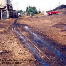
We are literally inside the Montgomery Ward complex in this photograph, looking south by southeast toward Larrabee, and beyond that, Chicago Avenue. Note the guard shack with the bumping post at the end of an unused spur. Their security guards were rather protective and the Milwaukee Road employees on this trip would have had to get permission to be in this area since it was fenced in with gates at both ends. The building on the right is the Montgomery Ward catalog building. The tall, newer looking building in the distance was their headquarters. Montgomery Ward, like the Milwaukee Road and tracks in this area, is just a memory. Trains passed through Montgomery Ward's property to and from businesses on the south end in 1980. Montgomery Ward was at one time a large rail customer of the Milwaukee Road through the early 1970s then their business shifted to trucks. In 2010 the former Catalog Building is now condos and offices.tb_mrha_CandESouthLine_10_1980_09
We are literally inside the Montgomery Ward complex in this
photograph, looking south by southeast toward Larrabee, and beyond
that, Chicago Avenue. Note the guard shack with the bumping post at
the end of an unused spur. Their security guards were rather
protective and the Milwaukee Road employees on this trip would have
had to get permission to be in this area since it was fenced in
with gates at both ends. The building on the right is the
Montgomery Ward catalog building. The tall, newer looking building
in the distance was their headquarters. Montgomery Ward, like the
Milwaukee Road and tracks in this area, is just a memory. Trains
passed through Montgomery Ward's property to and from businesses on
the south end in 1980. Montgomery Ward was at one time a large rail
customer of the Milwaukee Road through the early 1970s then their
business shifted to trucks. In 2010 the former Catalog Building is
now condos and offices.
tb_mrha_deeringline_09_1980_01
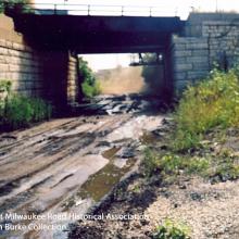
This view looks west by northwest along the Deering Line from a position just west of the underpass the Milwaukee Road used to dip below the C&NW North Line. To the left or south would be the North Branch of the Chicago River. A rail-served customer, Commercial Solvents, is ahead. This area was obliterated in the late 1980s and converted into a shopping center and parking lots.tb_mrha_deeringline_09_1980_01
This view looks west by northwest along the Deering Line from a
position just west of the underpass the Milwaukee Road used to dip
below the C&NW North Line. To the left or south would be the
North Branch of the Chicago River. A rail-served customer,
Commercial Solvents, is ahead. This area was obliterated in the
late 1980s and converted into a shopping center and parking lots.
tb_mrha_deeringline_09_1980_02
We’re now looking west at the underpass below the C&NW North Line. This time the photographer is east of the underpass. Today this area is inaccessible and part of a City of Chicago facility. The tracks are long gone. Note the double tracks.tb_mrha_deeringline_09_1980_02
We’re now looking west at the underpass below the C&NW North
Line. This time the photographer is east of the underpass. Today
this area is inaccessible and part of a City of Chicago facility.
The tracks are long gone. Note the double tracks.
tb_mrha_deeringline_09_1980_03
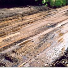
Perhaps the Milwaukee Road photographer wanted to highlight the poor conditions of the tracks on the Deering Line with this picture. They are there-buried in mud and oil.tb_mrha_deeringline_09_1980_03
Perhaps the Milwaukee Road photographer wanted to highlight the poor conditions of the tracks on the Deering Line with this picture. They are there-buried in mud and oil.
tb_mrha_deeringline_09_1980_04
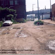
We’re inside the former International Harvester Deering Works north of Fulleron and west of Clybourn. This view looks south and towards the river. The spurs on either side serviced various buildings of the IH Deering Works which are occupied by other businesses in 1980. The building on the right looks relatively new however.tb_mrha_deeringline_09_1980_04
We’re inside the former International Harvester Deering Works north of Fulleron and west of Clybourn. This view looks south and towards the river. The spurs on either side serviced various buildings of the IH Deering Works which are occupied by other businesses in 1980. The building on the right looks relatively new however.
tb_mrha_deeringline_09_1980_05
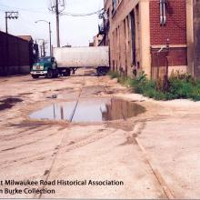
The camera is turned around the other way and faces north. Note how small truck trailers were in 1980 versus the behemoths used today.tb_mrha_deeringline_09_1980_05
The camera is turned around the other way and faces north. Note how small truck trailers were in 1980 versus the behemoths used today.
tb_mrha_deeringline_09_1980_06.5
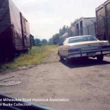
Looks like the expedition came across a relatively new looking boxcar sitting inside the Cotter & Company complex. It would be at the very end of the tracks inside the complex, near the intersection of Damen and Clybourn.tb_mrha_deeringline_09_1980_06.5
Looks like the expedition came across a relatively new looking
boxcar sitting inside the Cotter & Company complex. It would be at
the very end of the tracks inside the complex, near the
intersection of Damen and Clybourn.