Recent Posts

Pages: 1 2 [3] 4 5 ... 10
21
General Discussion / Re: 1921 tracks along river
« Last post by TBurke on July 05, 2023, 07:44:44 AM »
Nice catch. I am guessing that the Sun-Times building then later Trump Tower occupied that spot.

Reminder looking at the smoke in the air in the photo that in the old days bad air days were common in the industrial past when homes and industries burned coal.
22
General Discussion / Re: CNW shrine on the Mayfair branch
« Last post by TBurke on July 05, 2023, 07:42:50 AM »
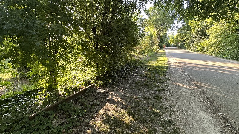
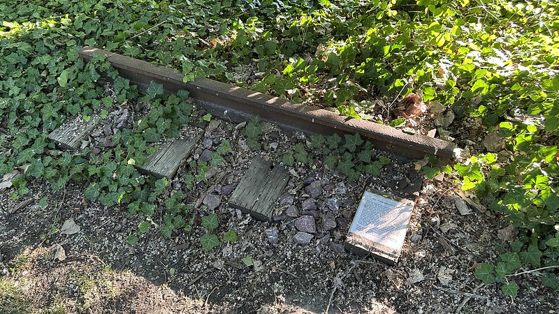
It's nice that they preserved a relic of the railroad heritage and noted it with a sign. I walked the 606 Trail when it first opened and was disappointed to not see a single rail preserved nor signage unlike the High Line Trail in NYC.

The date is a little off. UP continued to service Sun Chemical north of Touhy through at least 2003 and the tracks were in place as late as 2005.

Also this line at this point was actually the Weber Branch of Line. Mayfair was the line up to River Junction. From there it forked into the Skokie Subdivision to Northbrook and the Weber Line into Evanston.

http://industrialscenery.blogspot.com/2020/04/abanc-weber-yard-on-weber-canal-branch.html

Good digital copy of this out of print book on the line available here-

https://cnwhs.org/wp1/product/cnw-lines-north-of-mayfair-maps/

I have photos of the line when it was still in service and later, after operations ended but the tracks were still in place, in this album.

https://www.flickr.com/photos/39092860@N06/albums/72157658402425729/with/20903869703/

23
General Discussion / Re: photo missions
« Last post by TBurke on July 05, 2023, 07:28:36 AM »
How about retracing the route of the former Milwaukee Road Chicago & Evanston Line?

You could start at the former Buena Yard, just north of Irving Park Road where it interchanged with the CTA via a ramp. Then follow it south all the way to where it at one time crossed the North Branch of the Chicago River at Kinzie and Kingsbury and joined the main MILW tracks along Canal Street where they Metra/Amtrak tracks now cross Canal. It ran on the east side of Canal Street after crossing by where the East Bank Club now sits.

Your route would be primarily on city streets like Lakewood and Kingsbury. You could take a side trip onto Goose Island.

Show what artifacts like embedded tracks in the pavement are still left.

These maps should help.

https://www.flickr.com/photos/39092860@N06/albums/72157715114878692

Put your photos on Flickr also.

Tom
24
General Discussion / 1921 tracks along river
« Last post by themats on July 02, 2023, 12:31:29 PM »
From the Forgotten Chicago FB group, a photo of the Wrigley Building being built in 1921.  Tracks on the north side of the river are visible.
25
General Discussion / CNW shrine on the Mayfair branch
« Last post by Jeff Wingstrom on June 30, 2023, 12:01:31 PM »
Noticed this the other day. Just south of Pratt Ave. Pink lady ballast and all.


26
General Discussion / photo missions
« Last post by Jeff Wingstrom on June 30, 2023, 11:45:57 AM »
Hi all, with this biking habit of mine (now electrically-assisted) I'm spending a lot of time around rights of way whether operating or converted to a path or somewhere in between. If anyone has anything in Chicago(land) that'd be interesting to see a current picture of, post the location and I'll make my way to it for some forum photos. I'm based on the north side near Wrigley, range is city limits/surrounding suburbs. I can also do handlebar mount GoPro video footage. Anybody have any interesting requests?   :D   --Jeff

near Foster


27
General Discussion / Re: Buena
« Last post by TBurke on June 15, 2023, 03:35:12 PM »
The Milwaukee Road engines would work the Buena Yard up to where it became single track to go up the CTA ramp. There was a story where a MILW engine became derailed and a CTA electric engine helped rerail it. The overhead wires extended all the way to Irving Park.
28
General Discussion / Re: Buena
« Last post by Jeff Wingstrom on June 11, 2023, 03:29:56 AM »
Super cool!! The station looms, imposing and moody. Wish there were a shot looking south toward Irving Park; I wonder how far north of Irving MILW locomotives would get.
29
General Discussion / Re: customer spreadsheet
« Last post by raisin on June 04, 2023, 10:32:52 PM »
Wow, that area looks a little different these days. Thanks for posting!
30
General Discussion / Re: customer spreadsheet
« Last post by TBurke on June 04, 2023, 04:43:01 PM »
Along the Milwaukee Road C&E Line between Belden and Webster on the east side was Richardson Chemical. North of Belden were coal dealers.

Richardson Chemical lasted at least as long as 1979 as a rail served customer. It was gone by 1985 when I started photographing the line.

Here's a view of the plant being demolished to make way for townhomes.

https://www.flickr.com/photos/39092860@N06/20606052648/in/photolist-xoTpxN-xEExk5-LiHihj-YvHRsN-xG7WPa

https://www.flickr.com/photos/39092860@N06/20784606302/in/photolist-xoTpxN-xEExk5-LiHihj-YvHRsN-xG7WPa

South of Webster and north of Clybourn you had a Lakin tire facility and a liquor distributor on the east side. On the west side was the Birk Brothers Brewery.

https://www.flickr.com/photos/39092860@N06/29080135950/in/photolist-xoTpxN-xEExk5-LiHihj-YvHRsN-xG7WPa

Pages: 1 2 [3] 4 5 ... 10